Property Record
58 Main St, Helmetta, NJ 08828
NEARBY LISTINGS FOR SALE OR LEASE
-
-
View all Helmetta listings for sale on LoopNet.com
Property Detail
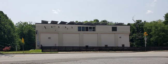
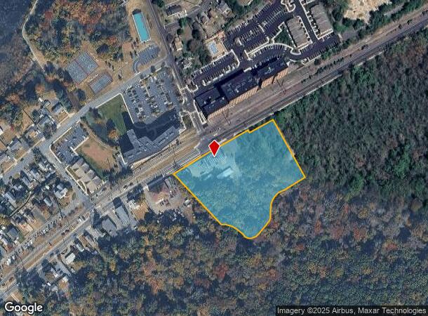
58 Main St
06-00013-0000-00039-02
3.37AC
Warehouse
Middlesex
AO
New Jersey
34023C0143F
39.2
2024
3.37 AC
2025
Brunswick
008103
Northern New Jersey
3,448 SF
Lakewood-New Brunswick, NJ
DEMOGRAPHICS near 58 Main St
1 Mile
3 Mile
5 Mile
2024 Total Population
4,514
47,062
121,711
2029 Population
4,535
46,883
120,985
Pop Growth 2024-2029
+ 0.47%
(0.38%)
(0.60%)
Average Age
42
42
45
2024 Total Households
1,711
16,450
44,748
HH Growth 2024-2029
+ 0.12%
(0.55%)
(0.89%)
Median Household Inc
$119,541
$127,311
$115,223
Avg Household Size
2.60
2.80
2.70
2024 Avg HH Vehicles
2.00
2.00
2.00
Median Home Value
$389,715
$457,826
$432,617
Median Year Built
1987
1980
1979
Nearby Places
Map Layers
Map Styles
 Street
 Aerial
- Restaurants
- Banks
- Shops
- Fitness
- Groceries
PUBLIC TRANSPORTATION
AIRPORT
Trenton Mercer
DRIVE
WALK
Distance
Trenton Mercer
45 min
27.4 mi
Newark Liberty International
DRIVE
WALK
Distance
Newark Liberty International
49 min
34.3 mi
Freight Ports
New York Container Terminal
DRIVE
WALK
Distance
New York Container Terminal
42 min
29.3 mi
SALE & LEASE HISTORY
LISTING DATE
SALE/LEASE

Oct 30, 2019
For Sale
Nearby Properties
Address
Land Use
TOTAL SIZE
Lot Size
Zoning
Address
Land Use
TOTAL SIZE
Lot Size
Zoning
161,447 SF
67.62 AC
R30
Address
Land Use
TOTAL SIZE
Lot Size
Zoning
1,154,372 SF
167.04 AC
LI
Address
Land Use
TOTAL SIZE
Lot Size
Zoning
1,145,608 SF
73.19 AC
LI
Address
Land Use
TOTAL SIZE
Lot Size
Zoning
983,940 SF
62.53 AC
LI
Address
Land Use
TOTAL SIZE
Lot Size
Zoning
29,951 SF
55.65 AC
R20
Address
Land Use
TOTAL SIZE
Lot Size
Zoning
87.65 AC
LI-4
Address
Land Use
TOTAL SIZE
Lot Size
Zoning
14,552 SF
484.47 AC
R20
Address
Land Use
TOTAL SIZE
Lot Size
Zoning
160,986 SF
60.24 AC
Address
Land Use
TOTAL SIZE
Lot Size
Zoning
29.74 AC
R30
Address
Land Use
TOTAL SIZE
Lot Size
Zoning
79.67 AC
I-3
Address
Land Use
TOTAL SIZE
Lot Size
Zoning
50.73 AC
I-3
Address
Land Use
TOTAL SIZE
Lot Size
Zoning
5.10 AC
Address
Land Use
TOTAL SIZE
Lot Size
Zoning
18.93 AC
R30
Address
Land Use
TOTAL SIZE
Lot Size
Zoning
44.80 AC
LI-4
Address
Land Use
TOTAL SIZE
Lot Size
Zoning
49.12 AC
LI-4
Address
Land Use
TOTAL SIZE
Lot Size
Zoning
56 AC
LI-4
Address
Land Use
TOTAL SIZE
Lot Size
Zoning
48.39 AC
LI-4
Address
Land Use
TOTAL SIZE
Lot Size
Zoning
299,532 SF
22.35 AC
LI
Address
Land Use
TOTAL SIZE
Lot Size
Zoning
8,512 SF
65.36 AC
MH
Address
Land Use
TOTAL SIZE
Lot Size
Zoning
413,092 SF
35.48 AC
LI-4
Address
Land Use
TOTAL SIZE
Lot Size
Zoning
227,175 SF
16.43 AC
LI
Address
Land Use
TOTAL SIZE
Lot Size
Zoning
34.73 AC
LI-4
Address
Land Use
TOTAL SIZE
Lot Size
Zoning
36.59 AC
I-3
Address
Land Use
TOTAL SIZE
Lot Size
Zoning
34.53 AC
I-3
Address
Land Use
TOTAL SIZE
Lot Size
Zoning
526,400 SF
40 AC
LI-4
Address
Land Use
TOTAL SIZE
Lot Size
Zoning
320,852 SF
39 AC
LI4R
Address
Land Use
TOTAL SIZE
Lot Size
Zoning
26.69 AC
LI-4
Address
Land Use
TOTAL SIZE
Lot Size
Zoning
2.53 AC
HR
Address
Land Use
TOTAL SIZE
Lot Size
Zoning
624 SF
210.30 AC
R30
Address
Land Use
TOTAL SIZE
Lot Size
Zoning
93,180 SF
0.65 AC
C-4
The World's #1 Commercial Real Estate Marketplace
Connect with us
© 2026 CoStar Group
The information above has been obtained from sources believed reliable. While we do not doubt its accuracy we have not verified it and make no guarantee, warranty or representation about it. It is your responsibility to independently confirm its accuracy and completeness. Any projections, opinions, assumptions, or estimates used are for example only and do not represent the current or future performance of the property. The value of this transaction to you depends on tax and other factors which should be evaluated by your tax, financial, and legal advisors. You and your advisors should conduct a careful, independent investigation of the property to determine to your satisfaction the suitability of the property for your needs.